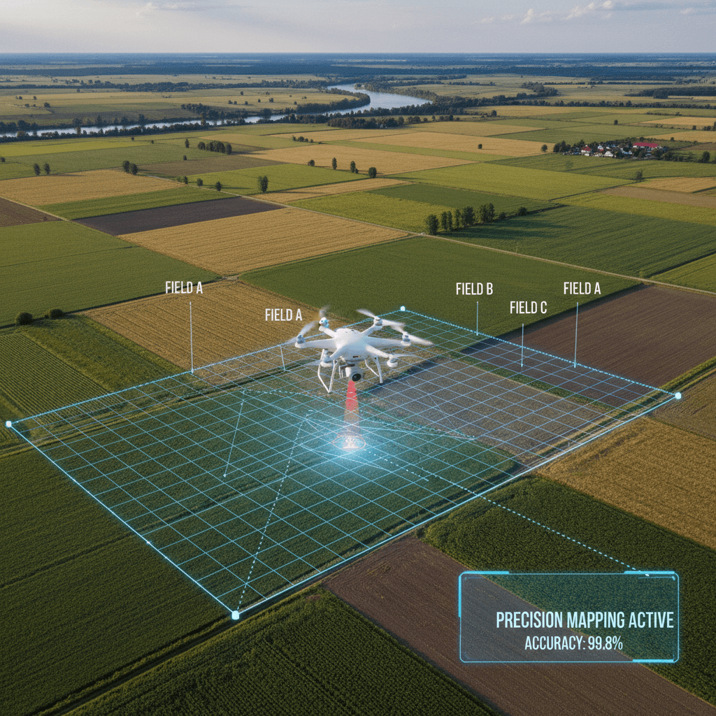
SFI 2026 drone survey requirements mandate the submission of high-resolution mapping data and detailed evidence packs to verify land parcel registration and action compliance. These surveys must produce actionable deliverables such as orthomosaics or remote monitoring imagery; these outputs satisfy RPA standards for remote inspections and precise environmental monitoring.
Navigating the evolving landscape of the Sustainable Farming Incentive often feels like chasing a moving target. As we approach 2026, the shift from passive payments to evidence-based delivery represents a significant hurdle for land managers and agronomists alike. It is no longer enough to simply claim actions on paper; the Rural Payments Agency now demands high-resolution, verifiable field data to justify every pound of investment. This transition places a heavy technical burden on busy operations. At SFI Land Solutions, we understand that compliance requires more than just a drone in the air. This guide breaks down the core data requirements for 2026, including the nuances of RTK accuracy and multispectral surveys. You will learn how to leverage precision farming data for PRF1 and why meeting the 48 hour turnaround is essential for maintaining operational momentum and securing your farm's financial future.
The 2026 Shift: From Passive Payments to Evidenced Delivery
The transition to SFI 2026 represents a fundamental shift in how agricultural subsidies are administered in England. Defra has consolidated the scheme into 71 distinct actions, moving firmly away from the passive payment structures of previous years. The current landscape is defined by a doing and documenting mandate; agronomists and land managers must now prove that environmental deliverables have been met through rigorous, data-backed reporting.
The Rural Payments Agency (RPA) is modernising its inspection framework, increasingly favouring remote monitoring and digital evidence packs over traditional on-site visits. In this high-stakes environment, the margin for error is slim. Traditional GPS and handheld photography often fall short of the precision required for RTK accurate field boundaries and rotational action compliance.
SFI Land Solutions serves as the technical bridge between raw field observations and RPA-ready documentation. By providing agronomists in Leicestershire and across the Midlands with high-resolution, multispectral data, we ensure that SFI 2026 drone survey requirements are not just met but exceeded. Our service, supported by transparent flat-fee pricing, enables professionals to contact our Market Harborough office and secure the evidenced delivery required to protect their clients' payments in an increasingly digital regulatory environment.
Core Data Requirements for SFI 2026 Drone Surveys
Meeting the SFI 2026 drone survey requirements necessitates a level of technical rigour far beyond simple aerial photography. To be considered valid evidence by the Rural Payments Agency (RPA), data must be rooted in absolute spatial accuracy. This begins with Real-Time Kinematic (RTK) corrected flight logs. While standard consumer drones rely on basic GPS with potential error margins of three to five metres, RTK technology provides centimetre-level precision. This ensures that RTK accurate field boundaries, buffer strips, and rotational action areas are mapped to the exact proportions required for payment compliance.
SFI Land Solutions utilizes the DJI Mavic 3 Multispectral hardware to achieve this high-fidelity output. This platform does not just capture images; it generates a comprehensive digital record containing time-stamped, geotagged imagery and sophisticated metadata. For agronomists, this means every pixel is anchored to a specific coordinate on the Earth's surface, creating an immutable audit trail that satisfies digital record-keeping mandates.
Technical Requirement | Professional Drone Data (RTK) | Standard Hobbyist Drone |
|---|---|---|
Positional Accuracy | 1–3cm horizontal accuracy | 3–5m average error |
Metadata | Time-stamped, geotagged, multispectral bands | Basic EXIF data only |
Evidence Quality | RPA-compliant digital records | Illustrative only; not for mapping |
Sensor Type | Multispectral (NDVI/Red-Edge) | Standard RGB (Visible light) |
In contrast, hobbyist drone footage often lacks the necessary metadata and positional accuracy for official land parcels. Without RTK correction, a drone survey may misrepresent the size of a cover crop area or the placement of a herbal ley, leading to potential payment penalties or boundary disputes. Valid data requires specific reflectance information and consistent sensor calibration. By providing these technical 'must-haves' through our transparent flat-fee pricing, we ensure that rural professionals can contact our Market Harborough office with confidence that their data will stand up to the most rigorous RPA inspections.
Unlocking PRF1: Precision Farming and Variable Rate Data

The PRF1 action under SFI 2026 provides a payment of £27 per hectare, per year, for adopting precision farming approaches to nutrient management. To satisfy the requirements for this action, agronomists must move beyond visual estimations. A standard green photo captured by a consumer drone or satellite is insufficient because it lacks the calibrated reflectance data necessary to build accurate variable rate prescription maps.
SFI Land Solutions utilises the DJI Mavic 3 Multispectral to capture specific wavelengths across four distinct bands: Green, Red, Red-Edge, and Near-Infrared (NIR). While the human eye only detects stress once a crop begins to yellow, multispectral sensors identify physiological changes much earlier. The Red-Edge band is particularly critical; it sits on the boundary between visible red light and NIR, acting as a highly sensitive indicator of chlorophyll content and plant health. This allows for the detection of nutrient deficiencies or moisture stress before they become yield-limiting.
Data Type | SFI Compliance Utility | Application in PRF1 |
|---|---|---|
RGB Photography | Visual record only | Identifying large scale failures |
NDVI (Multispectral) | Quantitative health index | Biomass assessment and VRA base |
Red-Edge Reflectance | Early stress detection | Fine-tuning nitrogen timing |
Prescription Maps | Digital audit trail | Direct upload to spreader controllers |
By converting these reflectance values into NDVI (Normalized Difference Vegetation Index) maps, we provide agronomists with the high-resolution evidence needed to justify variable rate applications. This data serves as a robust component of the SFI 2026 drone survey requirements, ensuring that every hectare claimed under PRF1 is backed by scientific measurement rather than guesswork. Our transparent flat-fee pricing allows for regular monitoring, giving professionals the agility to contact our Market Harborough office and receive processed, RTK-accurate data within 48 hours of a flight.
Field Boundary Compliance and RTK Accuracy

Compliance within the SFI 2026 framework begins with the absolute spatial integrity of land parcels. While consumer grade GPS is often sufficient for general navigation, its three to five metre error margin is a significant liability when documenting specific actions. For agronomists, a five metre drift along a one kilometre buffer strip can result in an area discrepancy of half a hectare, potentially triggering payment penalties or boundary disputes with the Rural Payments Agency (RPA) during a digital inspection.
Utilising Real Time Kinematic (RTK) positioning via the DJI Mavic 3 Multispectral eliminates this margin of error. RTK provides the centimetre level accuracy essential for defining RTK accurate field boundaries and conducting detailed hedgerow assessments. This precision is a fundamental part of meeting SFI 2026 drone survey requirements, especially for rotational actions. Defra has stipulated that the area of rotational actions cannot exceed the total area established in Year 1. Inaccurate initial mapping can inadvertently lock a client into an unworkable cap for the remainder of their agreement. By securing high fidelity data through our transparent flat-fee pricing, surveyors can ensure that every square metre is defensible. Professionals planning for the 2026 application windows should contact our Market Harborough office to establish precise baseline mapping.
Specific SFI Actions Supported by Multispectral Surveys
The transition from mapping boundaries to documenting specific in-field actions is where multispectral data becomes an essential tool for agronomists. Under the SFI 2026 framework, payments are increasingly tied to the successful establishment and ongoing management of environmental features. Providing the Rural Payments Agency with high-resolution, time-stamped data reduces the risk of payment reclaim and simplifies the annual declaration process.
For agronomists and rural surveyors, multispectral surveys provide a visual and analytical record that far exceeds the detail of a standard field walk. This data serves as the foundation of a digital evidence pack, meeting the SFI 2026 drone survey requirements by capturing objective metrics of crop and soil health.
SFI Action | Financial Value | Primary Drone Evidence Output | Compliance Utility |
|---|---|---|---|
SOH3 (Cover Crops) | £163/ha/yr | High-res orthomosaics (ground cover %) | Proves establishment and biomass density |
SAM3 (Herbal Leys) | £224/ha/yr | NDVI and Red-Edge health indicators | Verifies successful mix establishment |
CIPM3/4 (IPM) | £45–£55/ha/yr | Zonal stress maps | Documents monitoring and justifies targeted inputs |
In SOH3, the primary requirement is maintaining green cover over winter. A high-resolution orthomosaic provides a complete map of the parcel, allowing agronomists to calculate exact ground cover percentages. This is significantly more robust than a handful of ground-level photos which may miss large gaps in establishment. For SAM3, multispectral sensors identify variations in biomass that suggest where certain species in a herbal ley mix may be struggling. This allows for remedial action before an inspection occurs.
In the context of Integrated Pest Management (CIPM3/4), drone data acts as a permanent log of crop stress. By identifying specific zones of pest or disease pressure through Near-Infrared bands, agronomists can justify variable rate applications or localized interventions. Utilizing our transparent flat-fee pricing, professionals can incorporate these detailed surveys into their consultancy packages. To discuss specific parcel requirements for the upcoming season, contact our Market Harborough office for technical support.
The 48 Hour Turnaround: Why Speed Matters for Agronomists

In the fast-paced agricultural calendar of Leicestershire, timing is often the difference between a successful claim and a missed opportunity. With Window 1 for SFI 2026 opening in June and Window 2 following in September, agronomists and rural surveyors face immense pressure to finalize land management plans and verify establishment. SFI Land Solutions recognizes that delayed data is unusable data. By offering a guaranteed 48-hour turnaround on processed imagery, we ensure that RTK accurate field boundaries and health maps are in your hands before your next scheduled field walk or before an application window closes.
Our local presence in Market Harborough allows for rapid deployment across the Midlands. Once the DJI Mavic 3 Multispectral has completed its mission, we prioritize immediate processing to provide a comprehensive compliance pack. This pack directly addresses the core SFI 2026 drone survey requirements, including geotagged records and calibrated reflectance data ready for the RPA digital evidence portal. To keep your administrative overhead low, we operate a transparent flat-fee pricing model. This structure simplifies professional disbursements, allowing you to quote a fixed cost to your clients without the complication of hidden extras or mileage variables. For immediate assistance with your next mapping project, contact our Market Harborough office to book a survey that fits your tightest operational window.
Navigating the 2026 SFI drone survey requirements requires a balance of technical expertise and strict adherence to new data protocols. Ensuring your field data remains compliant is essential for long-term project success and operational integrity. If you want expert help navigating these complex standards, our team provides the specialized knowledge needed to streamline your workflows. You can learn more about our commitment to precision and how we assist clients with advanced land solutions. We are here to help you bridge the gap between regulatory changes and actionable insights.